SiriusXM Marine’s Fish Mapping is a new service that displays all the SiriusXM weather products on your chart plotter, then adds eight fishing features—including the analysis of professional oceanographers—to crunch all that satellite telemetry and show forecasted fishing hotspots directly on your multifunction display.
Even better, SiriusXM Marine can do that anywhere in its range, including U.S. coastal oceans up to 250 miles offshore. If you are accustomed to charting your own course after analyzing the various layers of telemetry, SiriusXM Fish Mapping allows you to analyze individual layers such as sea surface temperatures, sea surface height, plankton and weed lines on your chart plotter one at a time; you also will be able to see these sea-surface anomalies while at sea and out of cellular range.
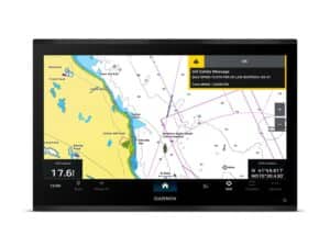
The new Fish Mapping service ($99/month) works only with Garmin multifunction displays using a Garmin GXM 54 SiriusXM weather receiver and a recently released firmware update for now. SiriusXM won’t confirm it, but we expect most major brands to jump on board soon.
As of this writing, the system was in beta testing, and we haven’t gotten our hands on it yet, but if its forecasting techniques can do what’s promised, it will be a real game changer.
Chances are, if you spend much time fishing offshore, you probably subscribe to ROFFS, Hilton’s Realtime-Navigator or a similar oceanographic analysis service that advises you of the most productive pelagic waters in the areas you plan to fish.
These services accomplish this by scientifically reviewing NOAA satellite data to find sea surface temperature breaks, sea surface height, eddies of warmer or cooler water, chlorophyll and plankton concentrations—areas that are most apt to hold fish.
ROFFS oceanographers, in addition to the hand-produced fishing plans they fax or email to subscribers, also make themselves available for satellite telephone calls for the most up-to-the-minute fishing information.
Don’t cancel these services, but add Fish Mapping as another tool in the box. SiriusXM Marine now overlays eight different fishing-data features on your chart plotter via satellite, then goes several steps further. Besides serving up the locations of temperature breaks and plankton concentrations, now oceanographers slice and dice that data for you, analyzing sea surface color telemetry and other data sets to recommend fishing locations directly on your chart plotter.
While they update all the information daily, they revise sea surface temperature contours every six hours and transmit it to those subscribing to the Fish Mapping service. It’s never been served up so neatly for recreational anglers before.
See how app-based satellite services have improved greatly.
Fish Mapping also includes all the features of Offshore Weather, SiriusXM’s top-tier weather service, which provides many data points that are critical to safe navigation. Those include lightning strikes, NEXRAD storm-cell attributes, tropical storm tracks, offshore wind and wave forecasts and marine observation buoys, among many others.
Fish Mapping rolls out in mid-August when Garmin offers an update, making it the first to partner with SiriusXM Marine on this new service. To take advantage of it, you will need Garmin’s 8400/8600 or 7400/7600 series chart plotters and a new GXM 54 SiriusXM Marine receiver.
With the ability to accurately forecast favorable fishing locations and update that information via satellite directly to the subscriber’s multifunction display, Fish Mapping from SiriusXM Marine is potentially a very powerful tool for the offshore fisherman.