Subscribe to Marlin magazine and get a year of highly collectible, keepsake editions – plus access to the digital edition and archives. Sign up for the free Marlin email newsletter.
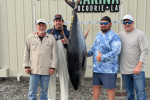
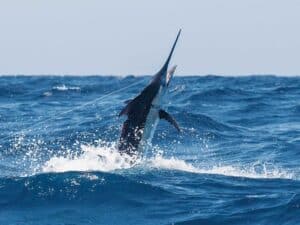
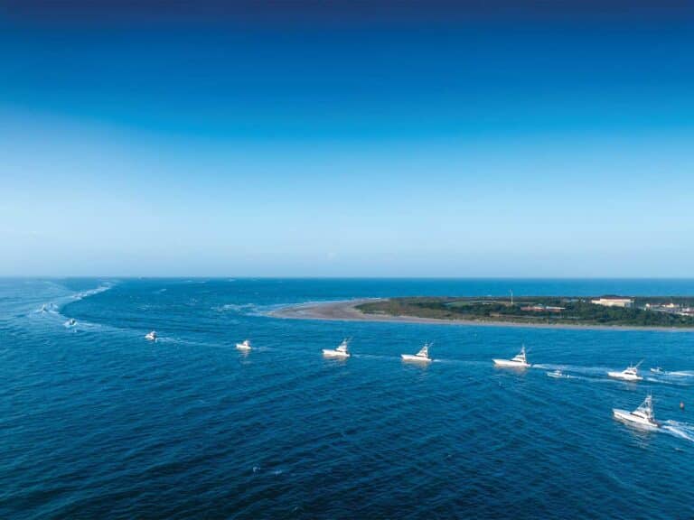
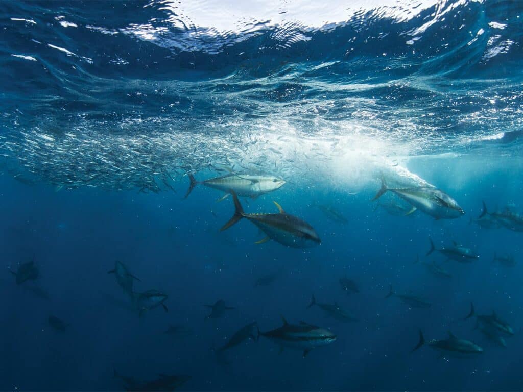
Summertime in New England brings unparalleled opportunities for big-game anglers to target large pelagics in the Northeast Canyons. At the continental shelf, where the bottom depth sharply drops from around 600 to 3,000 feet, these submarine canyons constitute deep valleys in the seafloor that attract a variety of marine predators. The fishing season, typically starting in June and ending in October, is dependent on days-long weather windows in which boats can run the approximately 100 miles offshore to reach these promising undersea features, fish for 24 to 48 hours, and then turn around and return home. Fishing trips to the canyons can be dreamlike, yielding six- or seven-headers from a “wolf pack” of 100-plus-pound bigeye tuna, dozens of white marlin, and trophy blue marlin and swordfish—all while under the observation of whale sharks, giant devil rays and other marine life.
These long-range trips also have great potential to be maddeningly frustrating, where anglers receive amazing catch reports during the ride out and arrive only to find a seemingly empty ocean, then return home empty-handed. For many anglers, whether we like to admit it or not, this is the harsh reality of many well-planned adventures. How is it that even the most seasoned crews can find the fish one day, only to be met by a blue desert on their next outing to the same spot under the seemingly same conditions?
Driving the Bite
Although canyons, humps and ledges are the fixed bathymetric features that anglers commonly target, it is the highly dynamic ocean conditions passing by these features that constantly shift the ideal fishing grounds where billfish and tunas can be found in abundance.
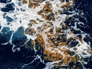
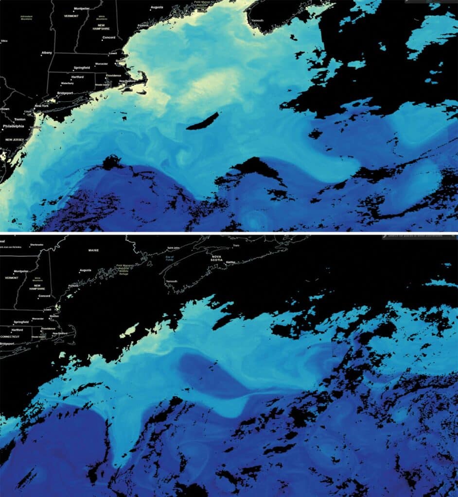
It’s no secret that by using near real-time satellite imagery, we can identify conditions that offshore anglers everywhere recognize as potential bonanzas, including where warm and clear, often “purple,” water approaches the continental shelf and yields major temperature and color breaks in the environment. Shifts in these fronts by just a few miles can make or break a fishing trip and alter a boat’s chance at success from one day to the next. For this reason, anglers in tune with the changing conditions religiously check sea-surface temperature and chlorophyll maps ahead of trips and try to pick the best spots for when they will be arriving at the canyons rather than, for example, heading out to the nearest canyon and then listening to radio chatter for information on where to try next.
The ephemeral nature of the famed canyons fishery off the northeast US, and others like it around the world, is driven by ocean currents that are constantly flowing and oscillating. Sometimes these currents directly meander up against the shelf break. On other occasions, they pinch off swirling eddies that move along or into a canyon. These eddies result in a collision of ecosystems, where the large game fish track their prey in hotspots that can suddenly burst to life just as quickly as they can vanish into nothing.
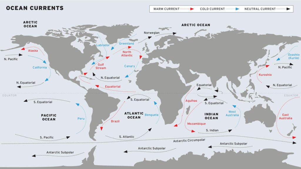
The canyons fishery described here is repeated along the western margins of all major ocean basins. The Gulf Stream is a western-boundary current of the Atlantic Ocean. In the Pacific, the Kuroshio Current also transports warm, tropical water into the productive temperate oceans of the mid-latitudes. Where the continental shelf nears the poleward-flowing Kuroshio, nations including Taiwan and Japan have long-established fisheries for pelagic predators that migrate to and live out key life stages in the region. In the Southern Hemisphere, along the western boundary of the South Pacific, flows the East Australian Current, which carries tropical water and pelagic predators in reach of ports along the Australian east coast. Unique to this region, the Great Barrier Reef is patrolled by large black and blue marlin, among other pelagic predators, as they migrate in the East Australian Current.
Satellite Oceanography Tips
So, how can we use the variety of satellite observations available to us? NASA offers a free web interface for the observations collected by NASA and the National Oceanic and Atmospheric Administration satellite, along with products from the European Space Agency.
Once we have identified a meander or eddy shed from a western-boundary current that is approaching the continental shelf, NASA and NOAA provide near real-time satellite observations that can aid in planning an offshore fishing expedition. Using both sea-surface temperature and ocean color (often looked at in terms of chlorophyll—a concentration that is a proxy for how much phytoplankton is in the water), we can hone in on sub-mesoscale streamers and filaments as they encroach on the shelf. Choosing a bathymetric feature such as a canyon or seamount that is underneath clear, warm water originating from a western-boundary current can be a good place to start searching for signs of life at the surface, also indicative of pelagic fish below.
Wind and Water
What causes these western-boundary currents that support large fisheries around the world? Ultimately, it is the interplay of the rotation of the Earth with winds over the ocean. At the global scale, western-boundary currents are driven by large-scale winds (the mighty trade wind, for example) that act to push the surface of the ocean downwind. As the wind pushes along the water, the rotation of the Earth causes it to deflect from going directly downwind. The Earth’s rotation imparts a force on the movement of water in the ocean, deflecting the current to the right of the wind in the northern hemisphere and to the left of the wind in the southern hemisphere. This rotational effect, which becomes stronger as you move from the equator to the poles, is called the Coriolis force.
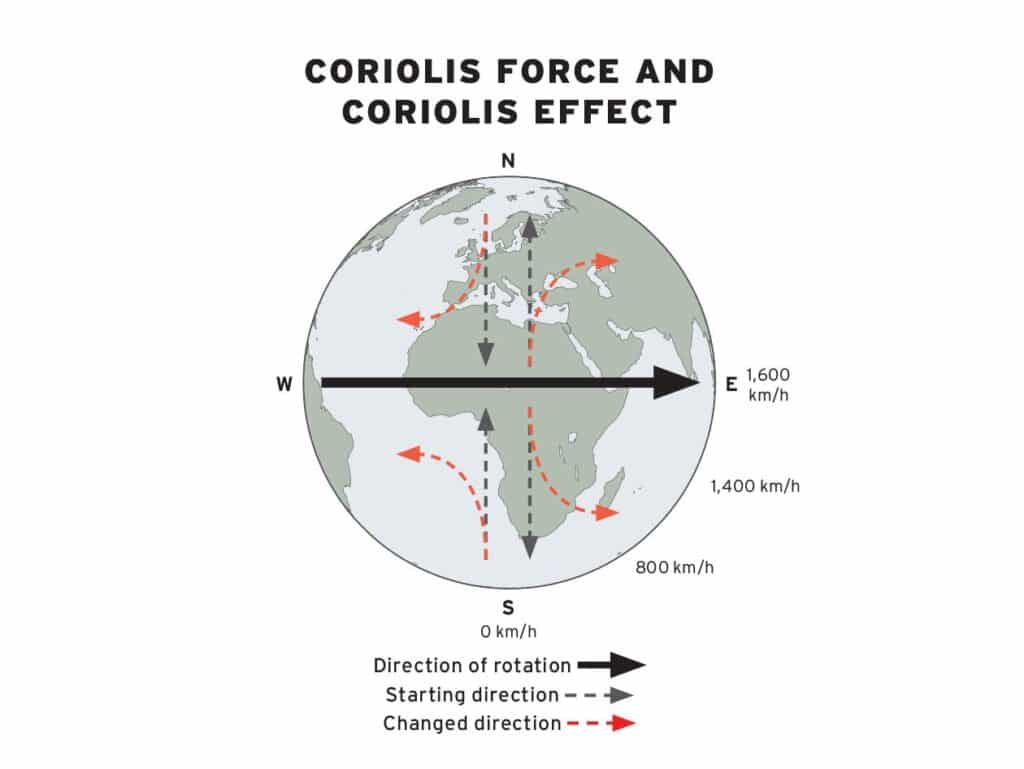
The Coriolis force, and how it changes with latitude, is what sets up the ocean gyre circulation. When looking at the gyre circulation in individual ocean basins, we observe a strong poleward current along the western edge of the basin that is “balanced” by an equatorward-boundary current along the eastern edge of the basin. This leads to clockwise gyre rotation in the North Atlantic and North Pacific and counterclockwise gyre rotation in the Indian, South Atlantic and South Pacific oceans. The associated western-boundary currents, however, do not flow directly along the continental shelf. Instead, the interaction of these currents with the shelf gives rise to large meanders in the current that can pinch off as eddies and bring warm-water pelagic species into the productive canyon ecosystems.
Eddies: Pockets of Life
The New England Canyons fishery is an example of what can happen when a meander of a boundary current, in this case the Gulf Stream, allows the pelagic ecosystems beyond it to impinge on the continental shelf, thus creating opportunities for anglers to interact with species that otherwise would be unreachable. The poleward direction of the meandering western-boundary currents, coupled with the background decrease in sea surface temperature with latitude, results in meanders that rotate anticyclonically (opposite in direction to the Earth’s rotation). When these anticyclonic meanders pinch off, they form eddies, with warm cores that contain volumes of tropical water, that are comparable in size to one of the Great Lakes. Once these eddies break from the boundary current, they move westward (again, due to changes in the Coriolis force with latitude) until they encounter the shelf and decay due to the slowing of the rotating currents by the drag created from water flow across topography.
Eddies like these are not singular columns of water. Instead, they are complex features with rich vertical structure that modulate the temperature and oxygen in the water column from the surface deep into the ocean. The vertical structure of anticyclonic eddies shed from western-boundary currents such as the Gulf Stream results in anomalously warm water from the surface to depths in excess of 2,000 feet. Warm eddies expand the depths at which predators can efficiently function, enabling them to spend more time hunting prey that migrates from the surface to greater depths each day. These favorable conditions can aggregate predator populations in and around anticyclonic eddies, effectively structuring a seamlessly featureless ocean. The opposite is true for cyclonic eddies shed from western-boundary currents that are relatively cold.
Timing the Bite
As eddies impinge on the continental shelf, they start to lose their rotational spin and fall apart, releasing the rich, tropical ecosystems contained inside. This results in unusually warm water and the appearance of tropical species such as tiger sharks, dolphinfish and blue marlin in otherwise cooler, more temperate water. Species associated with the western-boundary currents, including tunas, sharks and billfish, are transported to regions that otherwise would be out of their thermal niche. Using this information, we can start to get a handle on when we could expect conditions at a particular location to be productive to target large pelagics.
For example, at the time of writing this article, New Zealand had been in the midst of the best striped-marlin and yellowfin-tuna fishing it had experienced in the past two decades. Here, an eastward-flowing extension of the East Australian Current, known as the Tasman Front, intersects with the North Island and meanders, generating eddies. From our homes we can watch the evolution and eventual demise of large eddies in satellite images, yet the interaction of these currents with complex bottom structure ultimately determines the exact time when and location where stellar fishing can occur. For this, we need to look further into how these larger-scale currents and eddies interact with the seafloor.
The destruction of large warm-core eddies by the continental shelf unleashes a surge of energy that drives upwelling and downwelling in submarine canyons, concentrating prey. These conditions often create highly localized fishing opportunities that may last only a few hours—or, with luck, a few days—offering brief, but oftentimes unforgettable, windows.
Western-boundary currents such as the Gulf Stream and East Australian Current routinely shed these eddies, which carry tropical water and species into temperate zones. As the eddies decay near the shelf, their warm, oxygen-rich structure expands the depth range at which predators can effectively hunt. These eddies aren’t static features—they evolve, and their impact is shaped by interactions with bathymetric structures such as canyons and seamounts. When aligned with favorable conditions and interpreted through real-time satellite data, these eddies can reveal the places where prey and predator converge.
For those paying attention, these living currents unlock some of the most productive pelagic fisheries on Earth.