We’ve all heard of New Providence’s tourist-rich Atlantis resort on Paradise Island. And it’s likely we’ve all made this popular stop to check in and refuel on the way to other destinations such as the Exumas or San Salvador at some point, no doubt sampling a Goombay Smash or Bushwhacker or two in transit. Chances are, if you’ve checked both these boxes, then you’ve probably also tried some traditional Bahamian cracked conch or conch salad, but that’s not all this beautiful chain of islands has to offer.
The Bahamas aren’t just a collection of lively marinas and restaurant-style local seafood. For those who are interested in traversing the road less traveled with a need to explore an almost endless array of picture-perfect anchorages, untouched beaches, and world-class diving and fishing, you might want to set a course through the islands that are seldom frequented to experience some of the most diverse areas on the planet: This is the beauty of the southern Bahamas.
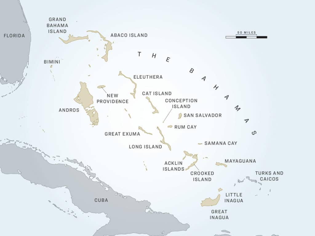
Conception Island
Often regarded as the most beautiful island in the Bahamas, Conception and its surrounding waters include almost 30,000 acres of nature preserve known as Conception Island National Park. Located between Cat Island to the north and Rum Cay to the south, the island itself has only about 2,000 acres of actual landmass.
On August 10, 1964, the Bahamas National Trust named this island as protected, but in 2011, the park was extended to protect the surrounding marine platform out to the 100-fathom mark. As a national park, Conception is considered to be one of the most important green sea turtle nesting sites in the Bahamas and sanctuary for many migratory birds. Conception is also the only known place in the world to be home to the Conception Bank silver boa. This species of snake was discovered by researchers in 2016, and it is the first new species of West Indian boa constrictor to be discovered in the past 73 years. Because they exist in such small numbers, the boas are considered critically endangered.
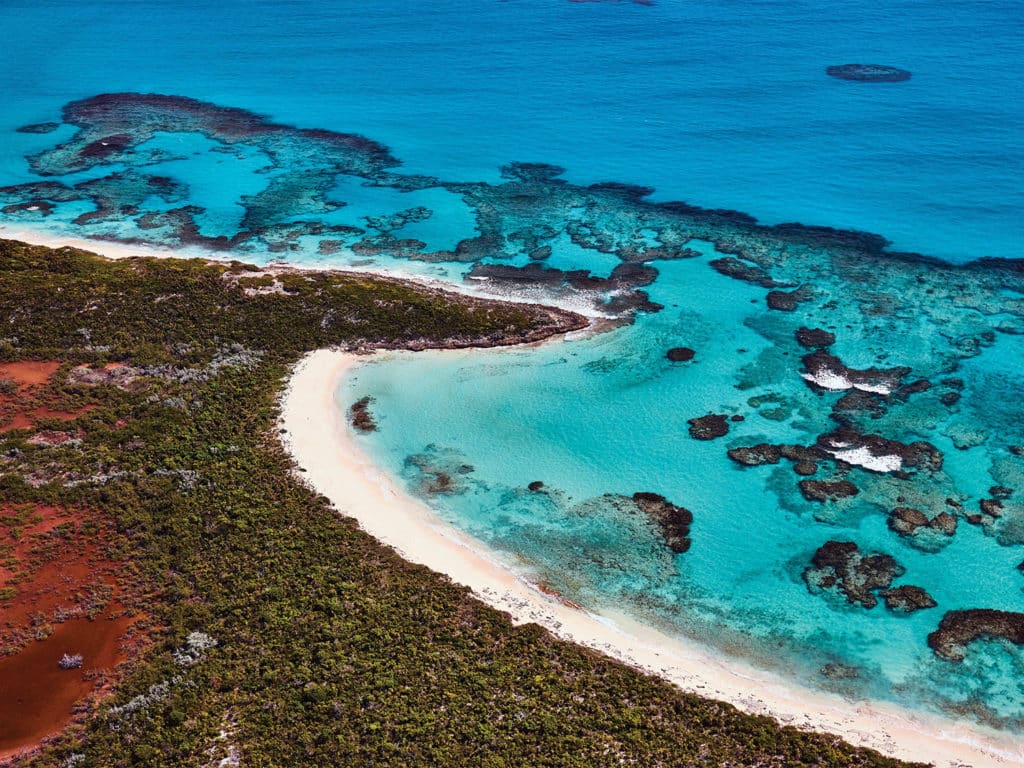
Conception Island is uninhabited but is visited by sailors, yachtsmen and fishermen alike. There is no marina, so anchoring or mooring at Conception is a must. The primary anchorage is at West Bay, a broad, crescent-shaped cove near the northwest corner of the island. And to add to its allure, it is fronted by a postcard-worthy white-sand beach, perfect for leaving your own footprints.
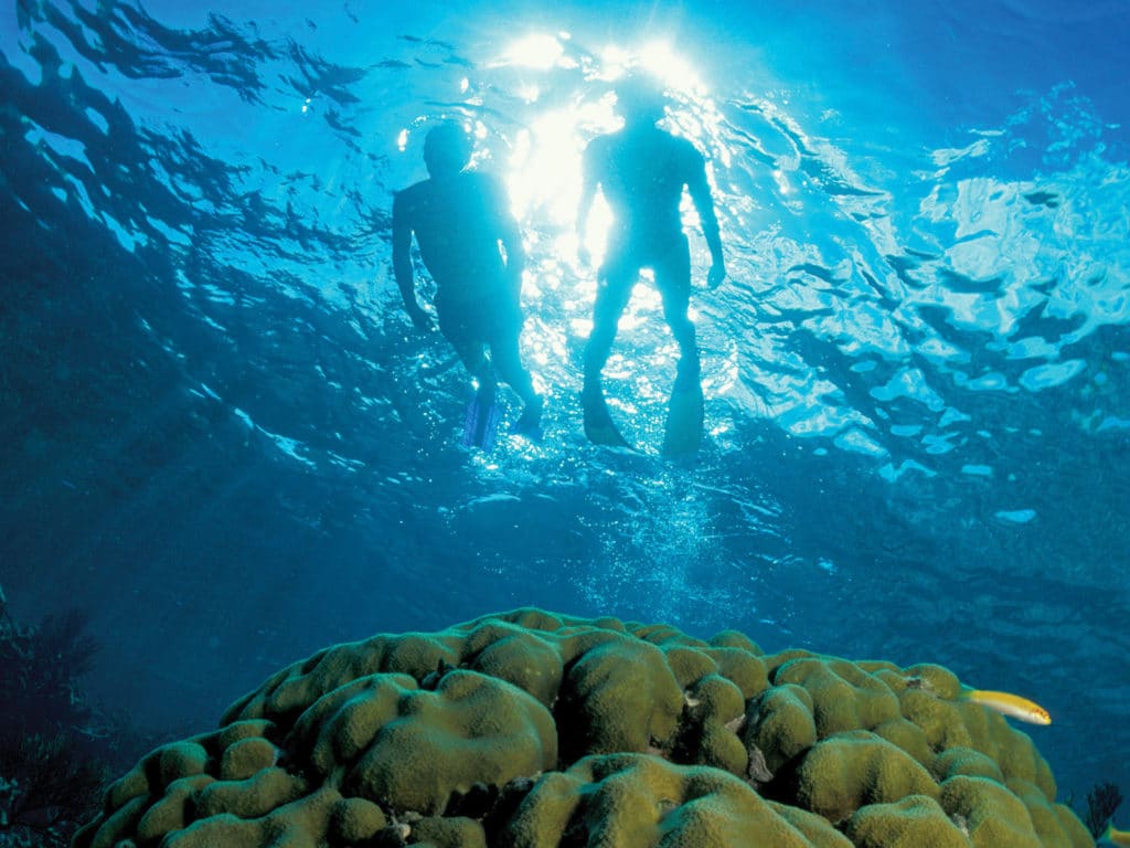
Thanks to the help of a donation by a private boater, the BNT has recently installed three new heavy-duty mooring balls in West Bay that are able to accommodate vessels up to 200 feet in length. The diving here, specifically the wall diving, is some of the Bahamas’ best. With South Hampton Reef on the north side of the island and multiple British and American shipwrecks to investigate, the underwater activities are plentiful. However, the fishing at Conception is rarely discussed or documented. Even with a steep edge and healthy reefs, coupled with the deep, open ocean surrounding the island, it generally receives light fishing pressure. Conception is a bountiful source for both bottom dwellers and pelagic species—just be sure to closely observe the park boundaries.
Rum Cay
Once known as Mamana by the indigenous Arawak Indians, Rum Cay is considered one of the best-kept secrets in the southern Bahamas, unless of course, you’re a fisherman. Then it’s no secret: Rum can be an offshore dream come true.
Located some 12 miles southeast of Conception Island, and approximately 20 miles southwest of San Salvador, Rum actually belonged to the combined district of San Salvador and Rum Cay before 1996. There are two interesting theories as to where the island received its modern name. One is that a West Indian ship wrecked offshore with a cargo of rum during the 1800s; the other is that it was named in honor of Scotland’s Isle of Rùm. Originally inhabited by Arawak and native Lucayans, artifacts and drawings from these early settlers dating back to the 1600s can still be seen at the protected historical site known as Hartford Cave on the north end of the island.
Also known for its fantastic diving, Rum Cay is home to multiple enticing open-water and wall dives. One of the most famous spots is the shipwreck of the HMS Conqueror. The shipwreck lies in 30 feet of water off Sumner Point Reef, becoming a part of the reef when it was lost in December 1861. HMS Conqueror was a 101-gun warship that served in the Crimean War and is preserved as part of the Underwater Museum of the Bahamas—and fiercely protected.
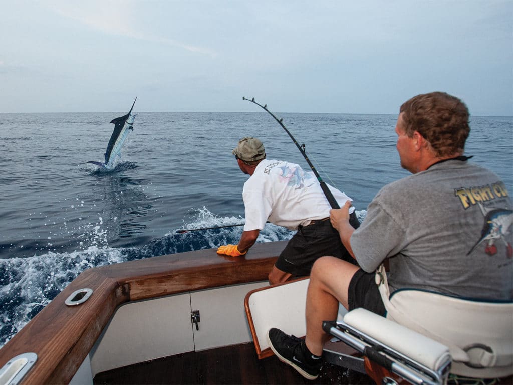
Rum’s location teeters on the continental shelf and presents some of best opportunities in the Bahamas for deep-reef, drop-off and wall dives. The site known as the Grand Canyon offers spectacular 60-foot coral walls that almost reach the surface. And given its location, Rum also presents the potential for some off-the-chart reef and offshore fishing. Depending on the conditions, the northeast and the southeast tips of the island produce the usual pelagic suspects—marlin, tuna, mahi and wahoo—with some regularity at the right time of year with the right conditions. Its close proximity to San Salvador makes it a very fishable day trip for boats wanting to explore Rum.
The abundance of living reef habitat that the inshore residents call home can make the bottomfishing and deep-dropping the stuff of legends. Currently, the only marina on Rum is located at Sumner Point and is unfortunately closed. And although some docks might still remain intact, there are no services available and the entrance is rumored to be silted in. Firsthand experience can tell you to be very careful should you decide to approach the small basin. The unmarked entrance is a maze of career-ending coral heads just waiting to make you part of the reef system.
Fortunately, there are some beautiful anchorages around Rum should the conditions allow. St. George’s Bay on the southeast corner within Port Nelson’s protected waters is possibly the best anchorage, with good holding around the island, and Flamingo Bay on the northeast side offers a secondary refuge should you so choose. Either way, it’s best to take your time getting into these bays—don’t let its sheer beauty distract you from the coral beasts below.
Crooked Island and Acklins
These two far-southeastern islands sit right near the top of my personal favorites list of places to visit, anchor and fish in the Bahamas. Located less than 40 miles southeast of Long Island’s Flying Fish Marina, Bird Rock and Landrail Point on the northwest tip of Crooked Island provide a safe and easy anchorage for any type of easterly wind condition. If you do stop, launch your skiff or tender and make your way to the beach to treat yourself to a nice home-cooked meal at the Crooked Island Lodge.
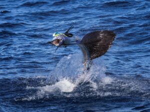
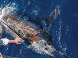
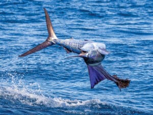
Spending some time there on many different boats over the years has proved quite rewarding. Not only have we caught good numbers of mahi, blue marlin and wahoo in the wintertime right on the edge of Landrail Point, it’s also only a 27-mile boat ride away from the famed Diana Bank. Diana will always hold a special place in my heart: The largest blue marlin I’ve ever seen in the Bahamas decided to crash our party there one day in May about 12 years ago. Unfortunately, the fish we estimated to be easily over 800 pounds came unglued about 10 minutes into the fight, but it’s those types of situations that can keep you coming back year after year, just waiting to cross paths with another legitimate sea monster.
Sitting on the southeast side of Crooked Island is Acklins Island. Acklins is one of the least-known and thus one of the most well-preserved islands in the Bahamas. Perfect for any traveling sportboat looking for a little seclusion, Attwood Harbour on the northeast tip is the best-protected and most well-known anchorage associated with the island. Attwood provides a beautiful and safe deepwater cove that could hold vessels of just about any length. Anchoring here and fishing the neighboring areas can be nothing short of spectacular. With short runs to the edge, the Plana Cays to the east or the islet of Samana Cay, just 22 miles to the north, you’ve got multiple options to check out. I’ve seen all of these areas be extremely productive over the years, with large numbers of tuna, mahi, and blue and white marlin.
As a matter of fact, Samana Cay is where I’ve seen my best-ever day of billfishing in the Bahamas. We did a few multiday trips back in 2012 that produced multiple double-digit billfish days fishing off Samana. I’m not saying I haven’t seen more fish in one day somewhere else in the world, but if you can have 10 or more bites from a variety of billfish species in one day, that is always a damn good day in my book.
Mayaguana and Inagua Islands
The easternmost out island in the Bahamas is Mayaguana. More isolated and less developed than any other, this inhabited island makes it a perfect destination for anyone seeking a secluded getaway. Mayaguana is unique in that it is the only Bahamian island that still bears its original Arawak name. The island was once visited regularly—and often favored—by traveling pirates until full-time residents started migrating there from nearby Turks and Caicos in the early 1800s.
Although it is rarely frequented (one of the biggest benefits of fishing there) by anyone but traveling boats en route to Turks and Caicos, the Dominican Republic and the rest of the Caribbean, those who make a point of testing these waters find that the marlin, tuna and wahoo fishing off Mayaguana can be nothing short of awesome.
Capt. Scott Stanczyk of Bud N’ Mary’s Marina in Islamorada, Florida, says Mayaguana’s fishery is a fairly unknown hidden gem, and “it still seems to be one of the last untouched treasures in the Bahamas.” Stanczyk was reluctant to share too many details besides a few blue marlin and tuna stories on the southeast and southwest corners of the island, citing how he’s seen similar great fisheries of the Florida Keys and the Caribbean succumb to the pressures of man.
Stanczyk and I agree that Devil’s Point and Big Cove on the southwest corner of Mayaguana can be really good if there is any prevailing southerly wind direction. And I have had some fine days fishing the southeast point when it was blowing out of the east. Unfortunately, there is no marina or facilities available on the island, but for those wanting to experience more than just a quick flyby, there is a good anchorage in Abraham’s Bay. A small public dock is available, but you’ll need a tender if you want to tie up and wander a spell.
If you happen to get the chance to stop by for a day, or even two, I highly recommend fishing the surrounding waters of Mayaguana—you won’t be disappointed. And I could never forget about the Inagua islands. Located approximately 50 miles south of Mayaguana, and only 30 miles southwest of West Caicos, Inagua is a unique stop for your tour of the southern Bahamas.
This southernmost island group includes two islands: Little Inagua, which is home to a national land and sea park, and Great Inagua, which is home to the Morton Salt Company, encompassing about 300,000 acres and producing over 1 million pounds of salt per year.
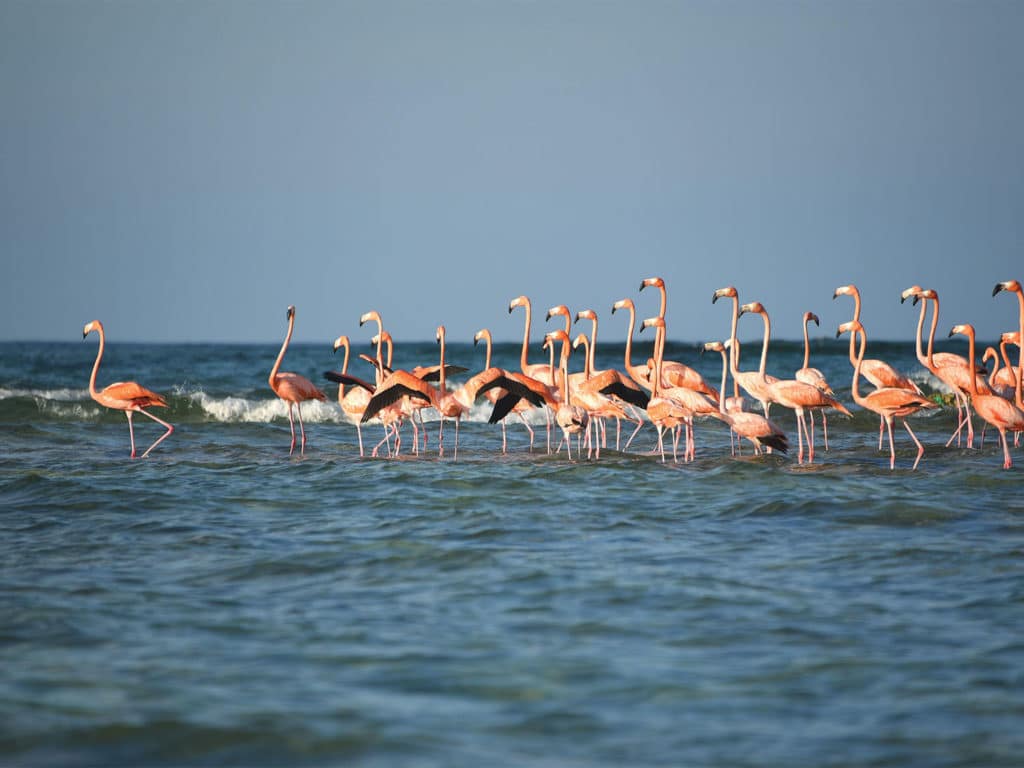
The Inagua islands are considered to be the bird-watching capital of the Bahamas and home to over 80,000 flamingos and 140 other species of native and migratory birds. But the flamingos aren’t just lazily soaking up the sun—they are a vital part of the Bahamian ecosystem and exemplify the essential symbiotic relationship that exists between man and nature.
The various processes of commercial salt production on Great Inagua significantly contributes to its coastal food chain. Algal mats are formed on the bottom of the Morton facility’s evaporating seawater reservoirs, and brine shrimp feed on the algae. And, just as expected, the flamingos and various other shorebirds eat the rose-colored shrimp. So, these flamingos are doing more than just looking pretty in pink.
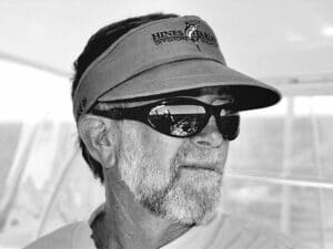
Ben Martin, a Bahamian captain from the Davis Harbour area near Cape Eleuthera, has spent nearly four decades running numerous private boats around these waters. Departing Long Island full of fuel and provisions, Martin will spend some time around the Mira Por Vos area at the bottom of Acklins before making his way to the light near the southwest corner of Great Inagua.
“We usually fish the edge outside the lighthouse and Molasses Reef,” Martin says. “You’ll find birds between there and the southwest bank, which has a ridge that shoots back offshore toward the southwest and some small humps that can really be good.” Martin also suggests he’s had some solid marlin and tuna days on a hump that exists northeast of the southwest bank off Little Inagua also. “Folks from the Turks and Caicos like that hump too.”
Martin says that early May through the middle of June gives you the best weather, but it can get pretty rough once the trade winds start blowing in July. And even after 40 years and amassing a wealth of knowledge, he still talks about his down-island camp-out trips with great passion: “We’re always on the lookout for the next fishing spot, so every day is a new adventure in the Inaguas,” he says.
So, while all of the islands of the Bahamas offer adventures any fisherman can take advantage of, it’s the southernmost ones that create a challenge and recall the old navigational routes of pirates and traders. By exploring off the beaten path, you open yourself up not to just another dusty rock, but to a new experience you’ll remember for a lifetime. I promise these quaint islands will leave you with a longing to visit them more than once.