MAR0115_Electronics
We’ve seen things change rapidly in electronics technologies as GPS devices essentially become WiFi-capable computers with interfaces for sonar, radar and positioning equipment. Looking at today’s forays into driverless cars by Google and unpiloted merchandise deliveries by Amazon, we had to take some time to speculate what is in store for the future of boats.
Microprocessor-driven engines and navigation gear coupled with electronic switching and controls have just begun to emerge, and we’ve barely tested their limits. But the only thing keeping boats from becoming robotic is the integration of technology that’s already available.
In fact, the Office of Naval Research recently made public its studies on robotic patrol vessels designed for defense. Much of the technology demonstrated is already available in the civilian sector. Creatively integrating today’s sophisticated digital marine sonar, radar, autopilots and programmable GPS navigators could create “smart boats,” just like Google’s smart cars or the ONR’s unmanned boats.
Existing Technology
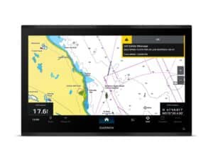
Furuno and Navionics were the first to create “danger zones” on electronic charts, enabling their GPS units to emit a warning if the vessel enters shallow water. Raymarine recently incorporated miniaturized GPS, accelerometers and heading sensors into its new autopilot system. Navico followed suit. The features were borrowed from smartphones and boast a dramatically smaller control module, beautifully simplified installation and better piloting capabilities. Does that sound new? Actually, electric trolling motors have used sonar and GPS input to navigate to a heading or a route or to follow bottom contours for years.
Garmin and Volvo Penta introduced integrated GPS and joystick controllers that allow the skipper to control the throttle, rudders and autopilot. Jog the stick to avoid an unexpected obstacle, then return to course with another nudge of the stick.
Navigation “red zones,” danger areas programmable by the user for hazardous territory, could easily be interfaced with the GPS and autopilot to stop navigation at those zone boundaries or to create an alternate course around them. More recently, automatic identification systems report and receive traffic information from other vessels on the waterway and are further tasked to report virtual aids to navigation (ATONs) for the skipper’s safety.
With the prospect of virtual ATONs, there is no reason why that data would not be automatically transferred to GPS charts once contact has been made so that it leaves a permanent digital track on the vessel’s system, which is especially important if the ATON has moved since the last chart download.
ATONs for no-wake zones can direct the autopilot to maintain the appropriate speed while allowing for manual throttle input to override it for particular maneuvering requirements. Radar input could create a virtual fence around a fixed or oncoming object that might not be noticed by the crew. Jog a joystick to overrule it or allow it, as user preference demands.
Sonar should likewise be integrated to reduce speed when entering a shallow zone or detecting an unexpected rise in bottom contour. The majority of these capabilities are not only conceivable and achievable, but most components are now used singly in various different pieces of equipment. Seamless integration is only a heartbeat away.
Sound far-fetched? Consider the sudden appearance in our airspace of the DJI Phantom 2 quadcopter drone costing less than $1,000 and boasting all the above technologies. Its firmware limits its operational altitude to 400 feet to stop it from entering controlled airport airspace, protecting general aviation from intrusion.
This little drone can even be user programmed to fly, hands free, any route and maintain a specific altitude at each waypoint. Finally, should the transmitter cease to offer input to the drone, it will hover in place for a minute or two, hoping to hear from you; if not, it returns to its departure point, lands and turns itself off.
A Future Ignored
A big part of the future could be upon us, but it is largely ignored by the boating public. Specifically, Rescue 21 and its interface with digital selective calling VHF radios has slipped through the cracks of rec boaters’ decks.
Much of Rescue 21, a land-based VHF radio system, was completed in 2006, surrounding virtually all of the continental United States to a minimum of 20 miles with a search-and-rescue safety net that requires only four simple things: [****1****] A working VHF radio, [****2****] An antenna that reaches 2 meters in height, [****3****] GPS data input from an onboard GPS, [****4****] An MMSI number easily obtained in an online application.
Trouble is, according to best estimates, including some offered by U.S. Coast Guard experts, less than 10 percent of all boaters have an MMSI number and even fewer have connected their GPS to their VHF, enabling the radio to transmit GPS coordinates.
The GPS data cables are a bundle of four small wires on the GPS that connects to a similar bundle from the back of the VHF. It’s an easy job but seldom done. The sad part of all this is that the DSC VHF radio system was designed specifically for recreational boaters, and they’re not using it.
Some manufacturers, like ICOM and Standard Horizon, are leapfrogging the GPS connection hurdle by building a GPS module into their radios. There’s an added cost, but it’s probably less than the cost to have a technician wire a VHF data cable to the GPS. They even offer handhelds with GPS technology inside.
Maybe in the future there will be a plug-and-play protocol for this connection, eliminating the gap that boaters and electronics installers resist hurdling.